
A photo blog for things relating to County Wexford (mostly of the stock photo variety). This blog is owned and run by Wexford Hub. Contact wexhub@gmail.com if you are interested in using one of our photographs.
Showing posts with label Streets. Show all posts
Showing posts with label Streets. Show all posts
Casa Rio, Wexford
A photograph of the Casa Rio houses on Distillery Road, Wexford. From what I've read; these houses were used by the foundry workers that used to work in Pierce's Foundry, which was situated where Tesco is today. These houses were built between 1945 and 1950. In the background, you can just about make out the spire of Bride Street Church. This was taken in June of 2015.
Kaats Lane, Wexford
A photograph of the bottom of Kaats Lane, which is in the Westgate area of Wexford Town. This lane connects Westgate with the car park at Dunnes Stores. In the past, it was home to Wexford Glass.

Keyser's Lane
A photograph of Keyser's Lane in Wexford Town. This old Norse lane runs between South Main Street and Crescent Quay. This lane is so old that its creation date is unknown!

Traffic on Wexford Quay
A busy Saturday morning on Wexford's Commercial Quay. Traffic was beginning to build up as the day grew closer to noon. A truck carrying hay drove by as I attempting to capture the hustle and bustle of the quay. Taken on the 6th of Nov, 2014.

Paul Quay, Wexford
A photograph of Paul Quay car park in Wexford Town. Taken from the Pay and Display car park opposite the Tourist Office. This was taken on the Easter Bank Holiday Monday in April of 2015. As you can see, a thick layer of fog had descended over the town at the time. To the left, you can just about make out some of the buildings on Wexford's Crescent Quay. On the right, you can barely see Wexford Bridge, which has been clouded out by fog.

Grogan's Road, Wexford
A photograph of Grogan's Road in Wexford Town. Best known for being home to a secondary school and the county's health clinic. This road connects the bottom of Summerhill Road with Carrigeen Street. On the left, you can see the green gates of the Presentation Secondary School. Photo taken on the Easter Bank Holiday weekend in April of 2014.

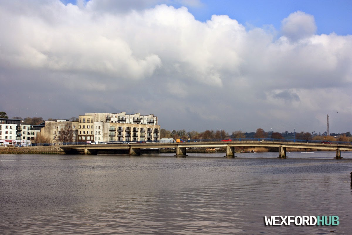
New Ross Bridge
A photograph of New Ross bridge. This bridge is apart of the important N25 road that connects Cork and Waterford with Rosslare Harbour and Wexford Town. The area behind it is known as "Waterside". This was taken in February of 2015.
Read more.
Read more.
New Ross
Photographs of New Ross, which is a small town in County Wexford, Ireland. These shots were taken on a bright and sunny day in February of 2015.
A photograph of the boardwalk on New Ross' quay-front:

The main N25 road flows through New Ross, causing a noticeable amount of traffic congestion at peak hours. Thankfully, there are plans to build a bypass for traffic going to and from Rosslare Harbour, Waterford and Cork.
In the background, you can see Michael Murphy Home Furnishing, T,J Bella's Traditional Fish & Chip and Byrne's opticians.

Another shot of the quay front. On the right, you can see the Supervalu supermarket and the entrance to one of the town centre's car parks.

A photograph of the boardwalk on New Ross' quay-front:
The main N25 road flows through New Ross, causing a noticeable amount of traffic congestion at peak hours. Thankfully, there are plans to build a bypass for traffic going to and from Rosslare Harbour, Waterford and Cork.
In the background, you can see Michael Murphy Home Furnishing, T,J Bella's Traditional Fish & Chip and Byrne's opticians.
Another shot of the quay front. On the right, you can see the Supervalu supermarket and the entrance to one of the town centre's car parks.
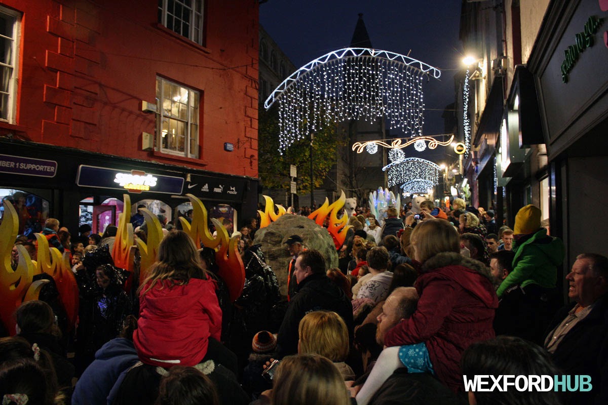
Parade on North Main Street, Wexford
A photograph of the Santa parade on Wexford's North Main Street. This was taken in November of 2014, during the Christmas season. As you can see, the place was flooded with people, making it extremely difficult to move! In retrospect, it might have been a better idea to hold the parade on Wexford's quay-front, which would have surely given the crowds more space.
Garda traffic control
A photograph of a lone Garda doing some traffic control at the entrance to Wexford's Common Quay Street. This was taken back in November of 2014, during the run up to the Santa parade, which was due to arrive in the Bullring. The Garda in question was preventing motorists from driving up towards the Bullring, which was packed with people.
Sugar House Lane, New Ross
A photograph of Sugar House Lane, which is a street in New Ross. This runs between the quay and South Street. In the distance, you can see the blue New Ross Seafood restaurant. This shot was taken in February of 2015.

Bullring, Wexford
Photographs of Wexford Town's historic Bullring, which was named after a blood sport called Bull Baiting. This area is seen as the heart of Wexford's town centre. Its origins date back to the 1600s, when the "sport" was introduced to the town. Since then, the area has become home to a busy market place, as well as iconic pubs such as Mackens. These shots were taken in September of 2014.
In the background of this picture, you can see the Bank of Ireland building.
Here is a shot of the Bullring seating area, where the Pikeman statue is. On the left, you can see Mackens (aka The Undertaker), which is a popular pub that has been around for over a hundred years. This was taken outside of the Hamilton's store.
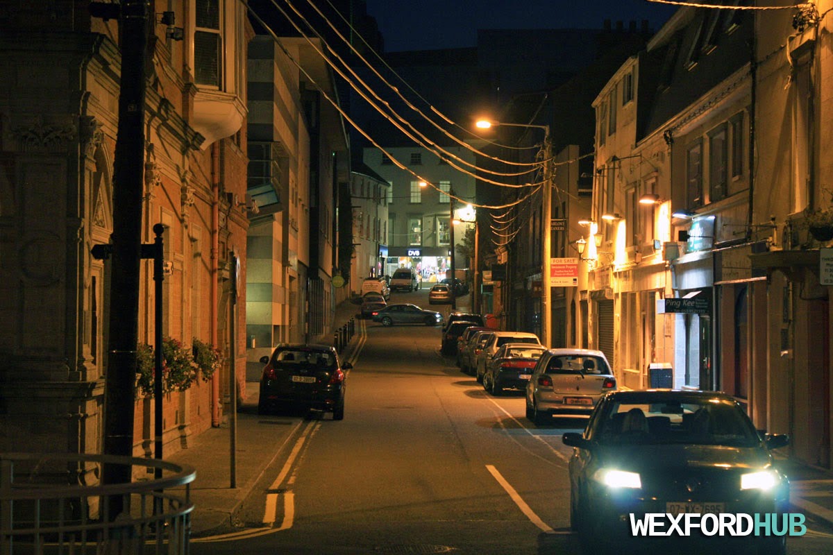
Anne Street, Wexford
A photograph of Anne Street in Wexford Town. This runs between the quay and Wexford's main street. At the very top you can just about make out the DV8 store, where Awear used to be. The red brick building on the left used to be home to the Wexford Credit Union. This street contains Wexford's Social Welfare Office and the Post Office. Taken at night in September of 2014.
Read More.
Read More.
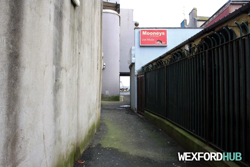
Roman Lane, Wexford
This is a photograph of a alleyway that is believed to be called Roman Lane. Situated beside the Stores building in Wexford, this particular lane runs between North Main Street and the quay. The name of this lane is disputed. According to local historian Nicky Rossiter, this is actually Oaks' Lane.
Photograph taken in the direction of North Main Street:

Taken in the direction of Wexford Quay. The red sign is for Mooney's on the Quay. The gates on the right cordon off Mooney's beer garden:
So, if this isn't the real Roman Lane; where is it?
Nicky Rossiter has pinpointed the lane's location as being beside Shaws and The Party Bar (which used to be Levingston's). As you can imagine, many of these small streets have been lost to progress, as the buildings and streets around them were heavily altered over the centuries.

Photograph taken in the direction of North Main Street:
Taken in the direction of Wexford Quay. The red sign is for Mooney's on the Quay. The gates on the right cordon off Mooney's beer garden:
So, if this isn't the real Roman Lane; where is it?
Nicky Rossiter has pinpointed the lane's location as being beside Shaws and The Party Bar (which used to be Levingston's). As you can imagine, many of these small streets have been lost to progress, as the buildings and streets around them were heavily altered over the centuries.
Selskar Street, Wexford
A photograph of Selskar Street in Wexford Town. This was taken during the Christmas season of 2014, when the festive lights were hanging across the main street.
On the left, you can see Nosh Coffee and Deadly Discounts (the yellow shop). On the right, you can see Euro Deal and Burger Mac.
This was taken in front of the Dunnes Stores supermarket in Redmond Square.

This photograph was taken in October of 2014. On the right, you can see Selskar Pharmacy, which is on the corner of Skeffington Street. On the left, you can see the Barnardos charity shop. This particular shot was taken in front of The Bike Shop.

On the left, you can see Nosh Coffee and Deadly Discounts (the yellow shop). On the right, you can see Euro Deal and Burger Mac.
This was taken in front of the Dunnes Stores supermarket in Redmond Square.
This photograph was taken in October of 2014. On the right, you can see Selskar Pharmacy, which is on the corner of Skeffington Street. On the left, you can see the Barnardos charity shop. This particular shot was taken in front of The Bike Shop.
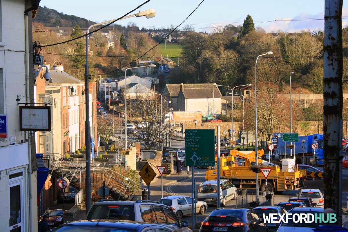
Castle Hill, Enniscorthy
A photograph of Castle Hill in Enniscorthy. Pointing in the direction of the bridge that leads to Wexford Town and Rosslare. In the background, you can also see Spring Valley. This was taken during a busy afternoon in February, 2015, just after all of the schools in Enniscorthy had closed for the weekend.
Church Street, Enniscorthy
A photograph of Lower Church Street in Enniscorthy, County Wexford. Taken outside of the constituency office of Fianna Fail TD John Browne. On the left, you can see the side of St. Mary's Church.

Enniscorthy Bridges
Photographs of the two one-way bridges that cross the River Slaney in Enniscorthy, County Wexford.
Here is a shot of the bridge that leads into the town centre area. This is the bridge you'll end up taking if you decide to drive in from the Wexford side. Taken from Island Road.

Here is the second bridge, which leads from the Dublin side. If you're driving from Dublin to Wexford, via Enniscorthy, then this is the bridge that you will cross over. As you can see, the waters were pretty choppy and a Perennial Freight truck was crossing at the time. In the background, you can just about make out the Boylesports outlet on Shannon Quay.

Here is a shot of the bridge that leads into the town centre area. This is the bridge you'll end up taking if you decide to drive in from the Wexford side. Taken from Island Road.
Here is the second bridge, which leads from the Dublin side. If you're driving from Dublin to Wexford, via Enniscorthy, then this is the bridge that you will cross over. As you can see, the waters were pretty choppy and a Perennial Freight truck was crossing at the time. In the background, you can just about make out the Boylesports outlet on Shannon Quay.
Enniscorthy, County Wexford
Photographs of Enniscorthy town in County Wexford. These were taken on the 6th of February, 2015. It was a bitter cold day and my hands were nearly falling off!
This is a shot of the River Slaney as it flows underneath the bridge that leads into the town centre. This was taken from the banks of Island Road.

A photograph of Island Road, which runs through the town. On the right, you can see Wallace's Alba:

This was taken at about 4PM, after the schools had just finished for the weekend. As you can see, the roads were full of traffic. This was on Castle Hill:

This was taken from the grounds of St. Senan's Hospital. In the background, you can see the Riverside Park Hotel, St. Mary's Church and Saint Aidan's Cathedral:

This is a shot of the River Slaney as it flows underneath the bridge that leads into the town centre. This was taken from the banks of Island Road.
A photograph of Island Road, which runs through the town. On the right, you can see Wallace's Alba:
This was taken at about 4PM, after the schools had just finished for the weekend. As you can see, the roads were full of traffic. This was on Castle Hill:
This was taken from the grounds of St. Senan's Hospital. In the background, you can see the Riverside Park Hotel, St. Mary's Church and Saint Aidan's Cathedral:
The Promenade, Enniscorthy
A photograph of The Promenade, which is a road that runs alongside the River Slaney in Enniscorthy. The name is derived from the word "promenade", which means is typically used to describe a long and open area that is next to a river. At the end of this road, you will find the Riverside Park Hotel.
This photo was taken on a cold afternoon on Friday, the 6th of February, 2015.

This photo was taken on a cold afternoon on Friday, the 6th of February, 2015.
Subscribe to:
Posts (Atom)